Community Ties and the Legacy of Disruptive Forces
Ties are made as a result of the interaction between our minds and the real world - our thoughts, feelings, and physical reactions to where we live and the surroundings, both built and living. They are closely linked with people's ideas of home or community, or how they imagine, experience, and give meaning to their living space(s). Without a doubt, the significance of the Park West Freeway project as disruptive force on Washington Park and the surrounding communities is important to consider when asking questions regarding people's lived experience of their community.
|
“The auto as the main method of transportation in the city should be considered an outdated, unnecessary and destructive concept" (1). So begins the West Side Citizens Coalition's 1973 report on its opposition the Park West Freeway, a highway that was planned to cut through the north and west sides of Milwaukee from I-43 to Sherman Boulevard along North Avenue. Opposition to the planned freeway had to contend with the bureaucratic and pragmatic logic of the Expressway Commission, the state institution responsible for the planning and construction of the freeway: “The project will, without a doubt, become an aesthetic highlight in the area" (2).
Throughout the planning phases of the Park West Freeway, the impact of the destruction of homes on the social fabric of the surrounding neighborhoods had been barely considered. "The very fact that it was more important to move cars than it was to preserve houses sends a message to the people that live there that these are not areas, houses, businesses that are held in high esteem" (3). Initially based on traffic congestion models, the location for the freeway was approved in the early 1960s and the Federal Highway Administration granted the "demolitions of acquired and vacated properties" to create the right-of-way for the freeway's construction in 1966, before the project plans were even finalized. By the time the West Side Citizens Coalition filed suit in federal court in 1971, 99% of the land needed had been acquired and 1,590 homes had been cleared. However, in 1977, it was decided by the Federal Highway Administration that the freeway would not be built on the grounds that there was considerable opposition, that it would sever established neighborhoods, and that it would be of limited utility, based on Milwaukee's freeway system at the time. Despite not having been built, the Park West Freeway left a noticeable scar on the neighborhoods surrounding the right-of-way, both physically and socially. The most conspicuous damage done by the project was the destruction of lived space in order to make way for one reserved solely for the automobile, completely altering the landscape and the way people interact with it. The removal of almost 1,600 households had undoubtedly disrupted immeasurable social patterns and ties that had previously been integral components of the way the residents must have experienced and imagined their own neighborhoods. To this day, over 40 years later, many areas in the right-of-way remain undeveloped, prolonging the disruption of social patterns and ties that are maintained by the residents and altering their lived experience. Making sense of any one person's ties is a challenging prospect, one which must uncover many nuances and complexities, even contradictions and inconsistencies, but even a brief look into someone's life can expose some intriguing ideas. Even more compelling is the experience of the newcomer or the immigrant. How do you make home in a new place? What occurs when one must update his or her idea of home? And more importantly, what is at stake? Our time spent with residents of the Washington Park neighborhood answered some of these questions and revealed how the ties that they create, maintain, and modify are interconnected with the way they experience their homes and communities. |
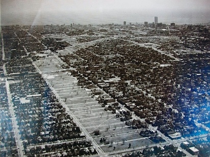
An easterly facing aerial view of the Park West Freeway right-of-way in the mid 1970s, while the completion of the project was being decided on in federal court. The Sherman Boulevard and North Avenue intersection is in the bottom right corner. Copyright: Park West Redevelopment Task Force Records collection, UWM Archives For further reading on freeway construction and transportation policy in Milwaukee and elsewhere:
Richard W. Cutler's book "Greater Milwaukee's Growing Pains, 1950-2000: An Insider's View" John Gurda's book "The Making of Milwaukee" Christopher J. Bessert's website on Wisconsin Highways and a more in-depth look at the Park West Freeway Kenneth Jackson's book "Crabgrass Frontier: The Suburbanization of the Unites States" Thomas W. Sanchez, Rich Stolz, and Jacinta S. Ma's report "Moving to Equity: Addressing Inequitable Effects of Transportation Policies on Minorities" View Washington Park/ Park West Map in a larger map This interactive map gives some context to the Washington Park neighborhood and the Park West Freeway. The blue color represents the partially completed Park West Freeway right-of-way. The red represents planned, but never started freeways, the Northwest Expressway and the Downtown Loop. The green represents the Park East Freeway, built, but later demolished due to lack of utility. Click on the objects in the map to read more.
1. West Side Citizens Coalition. (1973). The Park West and What it Means to Us. Milwaukee, WI. Author. - found in the UWM Library
2. U.S. DOT – FHWA, WisDOT, & Milwaukee Co. Transportation Division (1973, February 22). Draft Environmental Statement – Administrative Action for the Park Freeway and Spur. [EIS for Park West]. Park West Redevelopment Task Force Collection (Box 3, folder 11). UWM Archives, Milwaukee, WI. 3. John Gurda, interviewed by George Ananchev Spring 2012. |
